


Cauvels

tyntyn
User
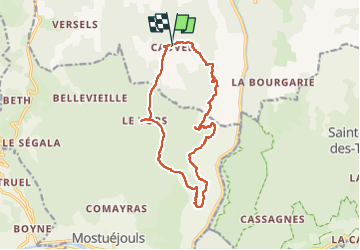

Length
15.2 km

Max alt
945 m

Uphill gradient
561 m
Km-Effort
23 km

Min alt
587 m

Downhill gradient
564 m
Boucle
Yes
Creation date :
2025-06-10 07:49:45.333
Updated on :
2025-06-10 14:25:47.918
6h11
Difficulty : Very difficult

FREE GPS app for hiking
 SityTrail
IGN / Geographical institutes
SityTrail Plus
The world is yours!
About
Trail Walking of 15.2 km to be discovered at Occitania, Lozère, Massegros Causses Gorges. This trail is proposed by tyntyn.
Positioning
Country:
France
Region :
Occitania
Department/Province :
Lozère
Municipality :
Massegros Causses Gorges
Location:
Saint-Rome-de-Dolan
Start:(Dec)
Start:(UTM)
516510 ; 4899632 (31T) N.
Comments